NASA: Venezuela Earthquakes Damaged Almost 60,000 Buildings
NASA: Venezuela Earthquakes Damaged or Destroyed Nearly 60,000 Buildings
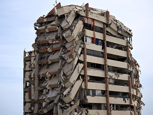

A rapid satellite imagery assessment released by NASA this week indicated that roughly 58,870 buildings in Venezuela were likely damaged or destroyed by last week’s devastating earthquakes.
The shocking assessment comes as international teams from the United States and other nations continue the search for survivors trapped in the rubble of collapsed buildings and other structures. Venezuela was struck by two earthquakes on Wednesday evening, one magnitude 7.2 and a magnitude 7.5 mere seconds later. The dual earthquakes caused widespread devastation in the northern coastal state of La Guaira and significant damage in the nearby capital city of Caracas and other states.
At press time, the Venezuelan socialist regime has documented at least 1,719 deaths, over 5,000 injured, and at least 15,000 individuals whose homes were affected by the earthquakes. United Nations officials estimate that some 50,000 people are still missing.
WATCH — U.S. Rescue Workers Pull Crying Infant from Venezuelan Earthquake Rubble:
NASA, using imagery taken by the European Space Agency (ESA)’s Sentinel-1 satellite radar, published its first rapid experimental assessment of the building damage caused by the earthquakes. The assessment was conducted by Corey Scher and Jamon Van Den Hoek, who are both researchers at the University of Oregon.
Per the satellites most recent pass, dated 25 June 2026 (10:16 UTC), approximately 58,870 buildings are believed to have been damaged or destroyed in Venezuela. NASA explained that it considers a building as damaged when at least 50 percent of its footprint area “falls on the coherence-loss damage map.”
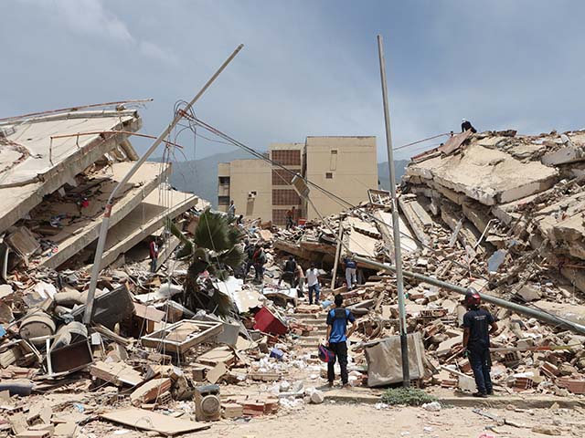
Residents search through the rubble of homes damaged during an earthquake and several aftershocks that struck La Guaira, Venezuela, Thursday, June 25, 2026. (AP Photo/Pedro Mattey)
“Building footprints are from Overture Maps. The damage threshold is not chosen by eye — it is calibrated against the USGS ShakeMap shaking field so that the false-alarm rate stays at or below 1 percent in lightly-shaken areas, where little or no structural damage is expected,” NASA explained in its assessment. “Damage detections concentrate where shaking was strongest (the central coast and the populated Caracas corridor), consistent with the earthquake’s intensity pattern.”
The assessment weighed two radar acquisitions obtained after the earthquakes between June 24-25 and compared them against a stack of pre-earthquake Sentinel-1 reference images acquired over the past year.
NASA emphasized that it is a “preliminary, rapid assessment” that reflects abrupt surface change consistent with damage.
“It has not been validated against field validated or compared to optical annotations of damage, and should be read as an indicator, not a verified building-by-building census,” the assessment read.
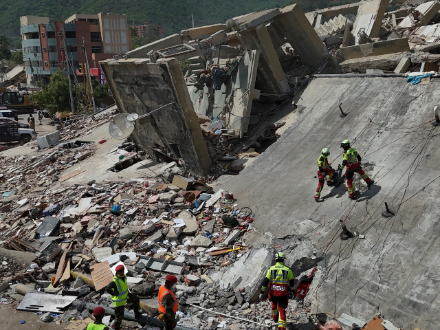
Mexican Army rescue workers search for people trapped in collapsed buildings after earthquakes struck La Guaira, Venezuela, Sunday, June 28, 2026. (AP Photo/Matias Delacroix)
NASA’s assessment far exceeds the most-recent estimates disclosed by the Venezuelan socialist regime. According to Jorge Rodríguez, the head of the Venezuelan National Assembly — and brother to “acting President” Delcy Rodríguez — Venezuelan authorities have documented “855” buildings that were “affected” by the earthquakes across the entire country, of which 189 completely collapsed and 666 suffered a partial collapse.
The Venezuelan socialist regime, after nearly three decades’ worth of mismanagement and corruption, left Venezuela grossly unprepared for natural disasters and without the adequate preemptive measures and safety policies to mitigate the devastating effects of an earthquake.
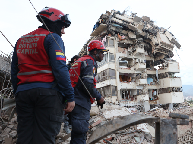
Rescue workers search through the rubble after an earthquake in La Guaira, Venezuela, Thursday, June 25, 2026. (AP Photo/Pedro Mattey)
The Venezuelan regime’s housing projects during the rule of late dictator Hugo Chávez and Nicolás Maduro, built with materials of questionable quality and without adequate earthquake prevention standards, could result in significantly higher death toll estimates in the near future. Over the past year, the broader housing project was denounced as a form of “political blackmail,” as its beneficiaries would not gain ownership of the properties and were at constant risk of losing them and other benefits should they attempt to protest against Maduro.
The Spanish newspaper ABC reported that the “Hugo Chávez housing complex” in Caraballeda, La Guaira, almost completely collapsed during the earthquake. Of the total 193 buildings, only three reportedly survived, and the rest completely collapsed. According to ABC, about 7,000 individuals resided in the housing complex.
Immediately after the disaster struck the South American nation, the United States deployed extensive relief efforts led by the U.S. State Department that include, but are not limited to, a regional Disaster Assistance Response Team (DART) and the logistical collaboration of the Department of War and the U.S. Southern Command (SOUTHCOM).
On Monday, the State Department announced that it has increased its financial assistance funding to Venezuela from $150 million to $300 million. The U.S. humanitarian funding has been directed to a range of non-governmental partners with “proven capacity” to deliver assistance in a quick and efficient manner. The State Department is also working with private partners to urgently deliver relief supplies to Venezuelan communities.
In addition to the United States, other countries such as El Salvador, Mexico, Israel, Italy, and Spain have sent rescue delegations, humanitarian aid, and other resources to help find survivors and attend to victims of the earthquake. The Venezuelan regime’s reported slow response and lack of relief efforts have led local citizens to denounce the situation to international outlets.
It is estimated that about 5,000 Americans presently live in Venezuela. A senior Trump administration official told NBC News on Monday that three American citizens are among the earthquake’s confirmed casualties and 12 more are reported as missing. More than 300 Americans have reached out to the U.S. State Department requesting assistance.
Christian K. Caruzo is a Venezuelan writer and documents life under socialism. You can follow him on Twitter here.
Badenoch blasts 'moaning' female Labour MPs over Burnham jobs 'quota'
Kemi Badenoch has told Labour women to earn a job in Andy Burnham's Cabinet instead of demanding they are handed jobs because of their gender.
The Tory leader lashed out today amid reports that female MPs are demanding the de-facto new prime minister introduce a 50:50 gender split 'quota' in his government.
Amid reports that former foreign secretary David Miliband is being lined up to return to the role, possibly with his brother Ed as Chancellor, one female minister also complained that Burnham could not have 'more Milibands than women' in the top posts.
But in a scathing article in the Times today Mrs Badenoch told them to 'stop moaning' and get chosen on merit instead of retreating into 'more of the failed identity politics that is holding back our country'.
'There are many, many reasons why you shouldn't have any Milibands in the cabinet,' she said.
'But complaining that the boys haven't given them the right jobs or that the boys are taking all the jobs, just shows that Labour's women still don't get it.'
The idea of quotas was also attacked by Baroness Jacqui Smith, Labour's Skills Minister.
Asked by Times Radio if Mr Burnham should reserve jobs for women, she said: 'No, I think what Andy Burnham should be doing is building the very best team around him to change this country.'

A letter written by the Women's Parliamentary Labour Party has called on Mr Burnham to ensure a 50:50 split between men and women in government jobs

Amid reports that former foreign secretary David Miliband (above, right, in 2010) is being lined up to return to the role, possibly with his brother Ed as Chancellor, one female minister complained that Burnham could not have 'more Milibands than women' in the top posts

But Mrs Badenoch told them to pipe down and get chosen on merit instead of retreating into 'more of the failed identity politics that is holding back our country'
A letter written by the Women's Parliamentary Labour Party and seen by the BBC has called on Mr Burnham to ensure a 50:50 split between men and women in government jobs after he succeeds Sir Keir Starmer.
'We are asking you to demonstrate this change from day one and address the toxicity and misogyny within our own party and government,' it said.
Labour has never had a female leader, while the Conservatives have had three, and Mrs Badenoch urged the government to follow its meritocratic example.
'If you run a meritocracy, then you do not have to worry about jobs for the boys,' she wrote.
'Every woman who is a Conservative MP, every woman who has ever won the leadership, has had to fight to get where she is.
'By contrast, Labour women are demanding guarantees from Burnham. But the truth is he doesn't have to give any guarantees.
'If none of Labour's women are prepared to get their hands dirty and challenge him for the leadership, their demands are toothless.'
'In fact, it's quite revealing that the women's parliamentary Labour Party has written to Burnham asking him to commit himself to at least 50 per cent female ministers.
'This has nothing to do with meritocracy. It is yet more of the failed identity politics that is holding back our country.'